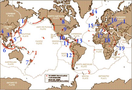
The following world map depicts the availability of geothermal resources in the world and shows accessible geothermal resources, especially countries along the circum-Pacific “Ring of Fire,” spreading centers, continental rift zones and other hot spots.

Indian Geothermal Potential
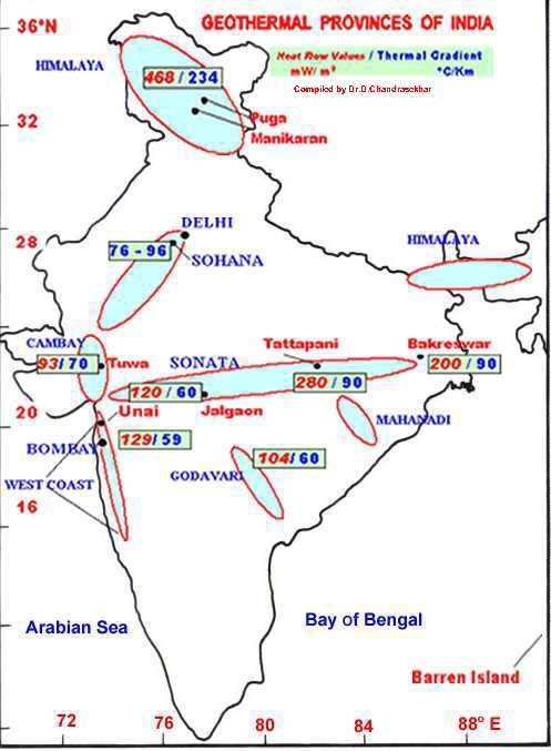
It has been estimated from geological, geochemical, shallow geophysical and shallow drilling data it is estimated that India has about 10,000 MWe of geothermal power potential that can be harnessed for various purposes. Rocks covered on the surface of India ranging in age from more than 4500 million years to the present day and distributed in different geographical units. The rocks comprise of Archean, Proterozoic, the marine and continental Palaeozoic, Mesozoic, Teritary, Quaternary etc., More than 300 hot spring locations have been identified by Geological survey of India (Thussu, 2000). The surface temperature of the hot springs ranges from 35 C to as much as 98 C. These hot springs have been grouped together and termed as different geothermal provinces based on their occurrence in specific geotectonic regions, geological and strutural regions such as occurrence in orogenic belt regions, structural grabens, deep fault zones, active volcanic regions etc., Different orogenic regions are – Himalayan geothermal province, Naga-Lushai geothermal province, Andaman-Nicobar Islands geothermal province and non-orogenic regions are – Cambay graben, Son-Narmada-Tapi graben, west coast, Damodar valley, Mahanadi valley, Godavari valley etc. Important geothermal locations are Puga Valley (J&K), Tatapani (Chhattisgarh), Godavari Basin Manikaran (Himachal Pradesh), Bakreshwar (West Bengal), Tuwa (Gujarat), Unai (Maharashtra) and Jalgaon (Maharashtra)
Geothermal Resources In India are depicted in the following graph:


